Key Takeaways
- A 24-36 hour shutdown leads to a backlog: vehicles needing transport keep increasing while trucks are parked.
- Expect 24-48 hour delays for vehicles already in transit.
- Expect 3-5 day delays for vehicles waiting for pickup after the storm.
- A second storm (potential bomb cyclone) is forecast for Sunday-Monday, which could extend delays further.
A Winter Storm Warning covering the entire Northeast corridor, including all five NYC boroughs, Long Island, northern New Jersey, and Connecticut, went into effect Friday, December 26, 2025.
It brought 4-12 inches of snow to the critical I-95 auto transport corridor between Philadelphia and Boston. The National Weather Service confirmed peak snowfall rates of 1-2 inches per hour during Friday evening, with Central Park recording 4.3 inches, the most snowfall NYC has seen since January 2022.
This storm affected almost all major interstate routes used by vehicle carriers in the Northeast such as:
- I-95
- I-80
- I-78
- I-287
- I-90 (New York State Thruway)
Wind gusts reaching 25-45 mph created blowing snow and near-whiteout conditions across the region.
Related: Winter Weather Vehicle Management: How Snow and Ice Impact Auto Transportation
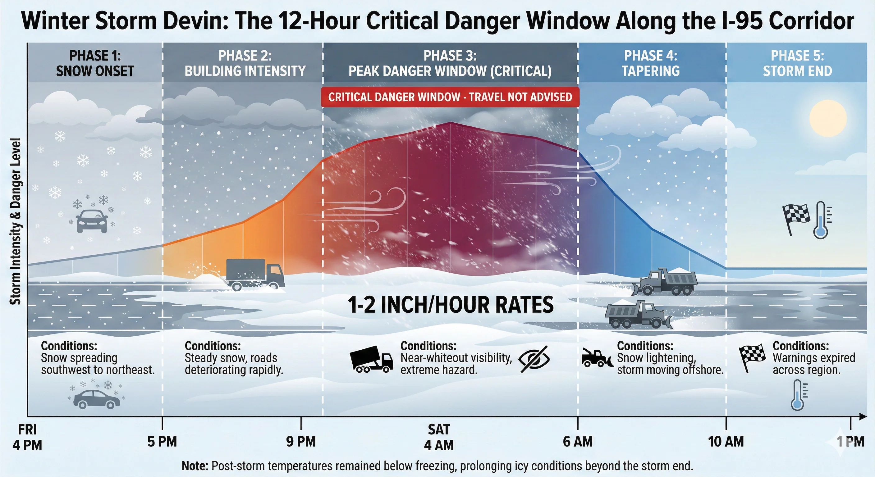
Storm Timing Created a 12-Hour Critical Danger Window
The storm moved through in stages that gave carriers limited time to plan.
| Phase | Timing | Conditions |
|---|---|---|
| Snow onset | 4:00-5:00 PM Friday | Snow spreading southwest to northeast |
| Building intensity | 5:00-9:00 PM Friday | Steady snow, roads deteriorating rapidly |
| Peak danger | 9:00 PM – 4:00 AM Saturday | 1-2 inch/hour rates, near-whiteout visibility |
| Tapering | 6:00-10:00 AM Saturday | Snow lightening, storm moving offshore |
| Storm end | 1:00 PM Saturday | Warnings expired across region |
Post-storm temperatures remained below freezing through Saturday, meaning treated surfaces stayed slick longer than during milder winter storms. Black ice remains a significant hazard through Saturday night.
Road clearing operations prioritized interstates, with state DOTs expecting major lanes passable by late Saturday afternoon, roughly 4-6 hours after snow ended.

What Routes Are Affected By Winter Storm Devin
The storm struck the heart of Northeast auto transport operations, affecting primary north-south and east-west corridors.
I-95 Corridor (Philadelphia-New York-Boston) took the hardest hit. This corridor, which normally handles the highest volume of vehicle carrier traffic on the East Coast, saw 4-8 inches of snow with near-whiteout conditions. New Jersey DOT imposed a full commercial vehicle ban from 3 PM Friday until 8 AM Saturday.
I-80 (Cross-country route) experienced restrictions at both ends:
- In New Jersey, commercial vehicles were banned entirely Friday afternoon through Saturday morning.
- In Pennsylvania, Tier 3 restrictions reduced speeds to 45 mph and banned empty trailers.
- In California’s Sierra Nevada, the route was completely closed due to multiple spinouts, with all tractor-semitrailer combinations banned from Applegate to the Nevada state line.
I-90/New York State Thruway presented hazardous conditions from the NYC line through Albany. Snow-covered pavement, icy spots, and heavy snow were reported across most sections. Buffalo-area carriers face additional delays with Lake Effect Snow Warnings projecting 12-18 inches in primary snow bands.
I-78, I-280 and I-287 (New Jersey) were under full commercial vehicle bans from Friday afternoon through Saturday morning, blocking key connector routes for carriers moving vehicles between the I-95 corridor and points west.
How This Storm Affects Auto Transportation
Winter storms create operational challenges that extend well beyond the storm itself. Federal regulations require drivers to cease operations when conditions become “sufficiently dangerous,” and carriers who suspend operations create a significant backlog when they resume.
The Capacity Crunch
Since auto transport operates on continuous flow, when a storm shuts down operations for 24-36 hours, vehicles don’t stop accumulating. Auction facilities, dealerships, and private sellers continue posting vehicles for transport, but the carriers who would normally handle those shipments are either parked waiting for conditions to improve or rerouted on longer paths.
When weather clears, carriers face roughly double their normal workload. A typical Friday-Saturday might have 100+ carriers servicing the I-95 corridor between Philadelphia and Boston. If weather grounds those carriers for a full day, Sunday brings not just Saturday’s normal volume but also Friday’s backlog and Sunday’s new orders, all competing for the same number of trucks.
Making matters worse: a potential bomb cyclone is forecast for Sunday-Monday that could bring another round of blizzard conditions to the Great Lakes and Northeast. If this second storm materializes as projected, carrier availability may not return to normal until midweek.
How Auto Transport Pricing Changes After Weather Events
When demand exceeds supply, carriers naturally serve the highest-value customers first.
For example, a carrier with 10 vehicles waiting doesn’t pick them up in booking order. Instead, the carrier evaluates the rate offered for each load, pickup and delivery locations, and how each fits with other vehicles already scheduled.
Customers usually offer $100-$500 above the original quote for immediate pickup, while customers insisting on the original quote wait.
As a result, this creates sudden rate increases. A customer quoted $900 before the storm may need to agree to $1,100-$1,400 for priority pickup during the post-storm crunch.
We typically offer customers the option to wait until carrier availability returns to normal and rates drop back to previous levels.
However, when a customer needs the shipment ASAP, we have no choice but to negotiate a new deal with the carrier for the best possible price so our customers can avoid being overcharged.
The Timeline
Pricing effects typically last 4-7 days after a significant winter storm. Given that a second storm may hit Sunday-Monday, customers booking in the days immediately following this weather event could pay 20-50% more than pre-storm rates, potentially through New Year’s Day.
Driver Hours Constraints
While no formal commercial-vehicle ban was issued across all states, drivers can only drive 11 hours within a 14-hour window before taking a mandatory 10-hour break.
A driver who spends Friday evening and Saturday morning parked waiting out weather doesn’t “save” those hours. If Saturday afternoon brings slow traffic on recently cleared roads with black ice concerns, the driver gets only 6-8 hours of productive driving instead of the usual 10-11.
Pennsylvania alone reported 280+ motor vehicle crashes and 300 disabled motorists during the storm. These conditions further slow carrier progress even after roads reopen.
Commercial Vehicle Restrictions That Impacted Carriers
Pennsylvania: Tier 3 Restrictions (most restrictive level)
- Routes affected: All interstates statewide, PA Turnpike I-76, I-70, and all extensions
- Banned: Empty trailers, RVs, buses, semis with double trailers
- Allowed: Loaded single trailers with chains or approved traction devices
- Speed limit: 45 mph on all restricted roadways
Source: PennDOT Official Announcement
New Jersey: Full Commercial Ban (lifted 8 AM Saturday)
- Routes affected: I-78, I-80, I-280, I-287, Route 440
- Banned: All tractor-trailers, empty CDL trucks, vehicles towing trailers
Source: NJDOT via WRNJ Radio
California I-80: Sierra Nevada
- All tractor-semitrailer combinations banned from Applegate to Nevada state line
- Carriers heading west turned around at state line
- Carriers heading east screened at Applegate. Maximum chains required to proceed.
Source: Caltrans Road Information
New York State Thruway
- No outright ban, but hazardous conditions have been reported across most sections of I-87
- Lake Effect zones near Buffalo under warning with 12-18 inches expected
Source: New York State Thruway Winter Travel Advisory
Conclusion
For this weekend’s Winter Storm Devin, the realistic timeline is:
- 24-48 hour delays for vehicles already in transit
- 3-5 day delays for vehicles awaiting pickup due to post-storm backlog and capacity constraints
- Potential extended delays through January 1 if the Sunday-Monday bomb cyclone materializes as forecast
Book shipments early when possible to lock in pre-storm rates. When a storm is forecast, expect delays of 24-48 hours for vehicles in transit and 3-5 days for vehicles awaiting pickup.
Customers with time-sensitive shipments may need to pay premium rates for priority service during the post-storm capacity crunch, especially with the holiday travel weekend pushing TSA to project 2.86 million travelers on Sunday, December 28, the busiest travel day of the season.
Monitor conditions at:
- Pennsylvania: 511PA.com
- New Jersey: 511nj.org
- New York: 511NY.org
- Connecticut: ctroads.org
- California: roads.dot.ca.gov
Sources
- CBS News: Winter storm snarls thousands of flights in the Northeast and Great Lakes
- Newsweek: Snowstorm Slams into the Northeast as Winter Storm Warning Issued
- ABC7 New York: Snowfall totals from NYC, NY, NJ and CT
- Fox 5 NY: How many inches of snow did we get in NYC, NJ, CT?
- PennDOT: Vehicle Restrictions Ahead of Friday Winter Weather
- WRNJ Radio: NJDOT imposes commercial vehicle restrictions
- New York State Thruway: Winter Travel Advisory Information
- Caltrans: I-80 Road Conditions
- NJ Governor: State of Emergency Declaration
- FOX Weather: States of Emergency triggered as major winter storm charges through the Northeast
- Al Jazeera: Over 1,500 flights cancelled as winter storm Devin hits US holiday travel
- National Weather Service: NYC 7-Day Forecast


